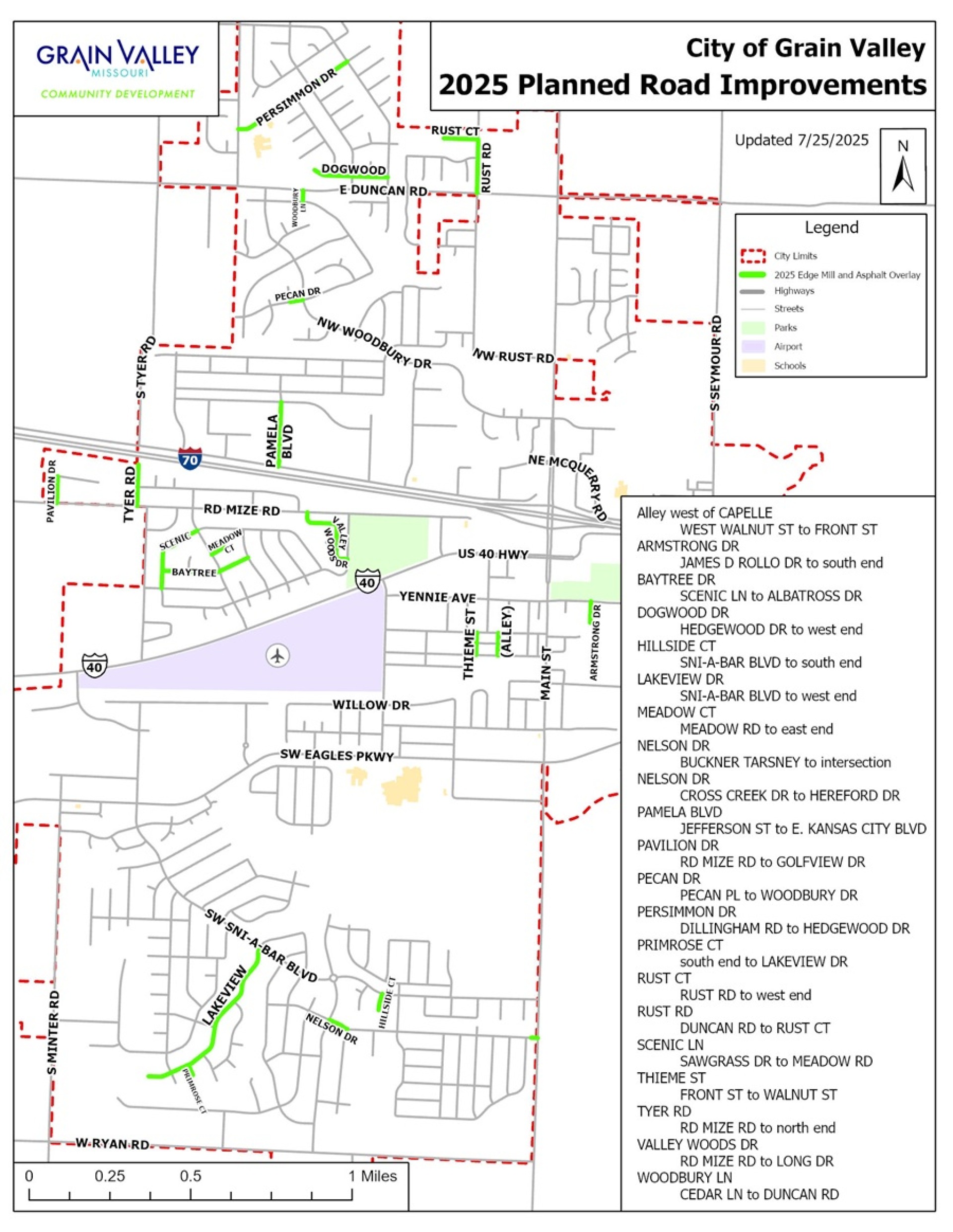
Projects
Community Development has budgeted funds for the following Capital Improvement Projects in 2025:
- Alley west of CAPELLE from WEST WALNUT ST to FRONT ST
- ARMSTRONG DR from JAMES D ROLLO DR to south end
- BAYTREE DR from SCENIC LN to ALBATROSS DR
- DOGWOOD DR from HEDGEWOOD DR to west end
- HILLSIDE CT from SNI-A-BAR BLVD to south end
- LAKEVIEW DR from SNI-A-BAR BLVD to west end
- MEADOW CT from MEADOW DR to east end
- NELSON DR from BUCKNER TARSNEY to intersection
- NELSON DR from CROSS CREEK DR to HEREFORD DR
- PAMELA BLVD from JEFFERSON ST to EAST KANSAS CITY BLVD
- PAVILION DR from RD MIZE RD to GOLFVIEW DR
- PECAN DR from PECAN PL to WOODBURY DR
- PERSIMMON DR from DILLINGHAM RD to HEDGEWOOD DR
- PRIMROSE CT from south end to LAKEVIEW DR
- RUST CT from RUST RD to west end
- RUST RD from DUNCAN RD to RUST CT
- SCENIC LN from SAWGRASS DR to MEADOW RD
- THIEME ST from FRONT ST to WALNUT ST
- TYER RD from RD MIZE RD to north end
- VALLEY WOODS DR from RD MIZE RD to LONG DR
- WOODBURY LN from CEDAR LN to DUNCAN RD
Download/Print the 2025 Road Improvements Map: .JPG or .PDF
__________________________________________________________________________________________________________
Thank you to our Public Works division for overseeing the following projects to completion in 2024:
- ADDIE LANE - MINTER ROAD to JOSEPH CIRCLE
- AZALEA CIRCLE - NW LONG DRIVE to south end
- CRESTVIEW DRIVE - RIDGEVIEW DRIVE to LEE ANN CIRCLE
- CROSS CREEK DRIVE - STONE BROOK DRIVE to STONE BROOK LANE
- CROSS CREEK LANE - STONE BROOK DRIVE to STONE BROOK LANE
- E.E. KIRBY ROAD - from US 40 HWY southward 645 feet
- FOOTHILL DRIVE - North end to south end
- HEDGEWOOD DRIVE - ROSEWOOD DRIVE to DILLINGHAM ROAD
- LOGAN DRIVE - CRESTVIEW DRIVE to SNI-A-BAR BLVD
- MAGNOLIA CIRCLE - NW LONG DRIVE to south end
- NW LONG DRIVE - NW SCENIC LANE to VALLEY WOODS DRIVE
- OAK WOOD LANE - HILLSBORO DRIVE to north end
- OLD 40 HWY - MAIN STREET to east city limits
- RIDGEVIEW DRIVE - CRESTWOOD DRIVE to SNI-A-BAR BLVD
- ROSEWOOD DRIVE - BIRCH COURT to HEDGEWOOD DRIVE
- ROYER DRIVE - EAGLES PARKWAY to BARBARA DRIVE
- ROYER DRIVE - BARBARA DRIVE to WILLOW DRIVE
- SAWGRASS DRIVE - BARR ROAD to MEADOW ROAD
- SILVERSTONE CIRCLE - NW LONG DRIVE to north end
- SILVERSTONE COURT - NW LONG DRIVE to south end
- SNI-A-BAR BLVD - US 40 HWY to SNI-A-BAR PARKWAY
- W WALNUT STREET - MAIN STREET to E KIRBY ROAD
Map · Grain Valley Community Development
711 Main Street · Grain Valley, MO 64029